One early project of the Sutherland Shire Environment Centre was The Great Kai’Mia Way, which arose from the insight of a number of individuals who had a long-term love and involvement in the Georges River Catchment. In 1998, the State Government established the Georges River Foreshores Improvement Program (GRFIP) to find means to improve the health of the Georges River.
The idea of the Great Kai’Mia Way arose from community concern for Botany Bay, the Georges and Woronora Rivers and an acknowledgement that parts of these river systems were under great environmental stress.
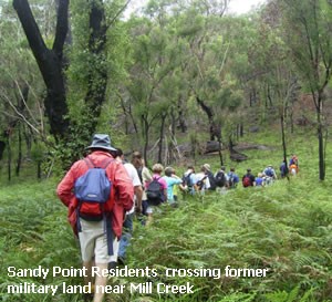
Sutherland Shire Environment Centre and Georges River Environmental Alliance recommended that a feasibility study be carried out into the establishment of a continuous system of trails and tracks along the foreshores of the Georges and Woronora Rivers. About 75% of the track already existed in the form of fire trails, cycle ways, service roads for various utilities. The plan was to link these routes into one spectacular trail.
It was a vision of over two hundred kilometres of sustainable pathways linking Botany Bay, the Woronora valley, large parts of southern and western Sydney, and the Illawarra Escarpment.
Planning NSW’s Georges River Foreshores Improvement Program funded the Environment Centre to conduct a feasibility study, and the Great Kai’Mia Way project was launched in 2002. Stage one of the project was completed and route options were plotted along the Georges and Woronora River catchments for walking tracks, cycleways, and even water transport.
The Project and Feasibility Study Report was released in 2004.
The Vision of The Great Kai’Mia Way

The vision that inspired the project also saw it become genuinely collaborative, involving broad participation on the part of Indigenous Elders; Local Aboriginal Land Council representatives; six state government and two local government agencies; a number of schools; and 24 community groups and NGO’s.
A diverse range of community groups participated, from precinct residents’ associations, wildflower and bushcare groups to cycling, canoe and Rotary groups. Partnering with stakeholders was valued as a strategic feature of the project, the fundamental principle was of stewardship. It was hoped participating organisations would play an ongoing role, progressively implementing the vision of the Great Kai’mia Way through each step, in partnership with landholders, land managers and the community.

Although the full extent of the “The Great Kai’Mia Way” has not been brought into being, it has been described as a concept rather than a blueprint. In this sense the project has proved invaluable, having been referenced for many years by councils, government agencies and community groups.
Natural systems are connected systems, and municipal boundaries bear no relationship to natural systems. Consideration of this interconnection is too often ignored by planning authorities.
The Great Kai’Mia Way advocated for the natural systems – such as wildlife corridors and water catchments – to be incorporated into municipal planning. The value and need for a connection to the natural world has an enduring relevance.
We hope that the vision of the study will continue to guide and inspire: the idea of connecting human and natural communities in the spirit of mutual care and respect.
The Report
Although the Way has not been implemented in full, some sections have been enhanced due to the ideas the Report inspired.
Contents and 2021 Forward: Sutherland Shire Environment Centre Chair, Dr Tassia Kolesnikow
Great Kai Mia Way Feasibility Study – Part 1: Executive Summary, Contents, Introduction, Chapter One, Chapter Two, Chapter Three (pt.1)
Great Kai Mia Way Feasibility Study – Part 2: Chapter Three (pt.2), Chapter Four (pt.1)
Great Kai Mia Way Feasibility Study – Part 3: Chapter Four (pt.2)
Great Kai Mia Way Feasibility Study – Part 4: Chapter Four (pt.3)
Great Kai Mia Way Feasibility Study – Part 5: Chapter Four (pt.4), Chapter Five, Chapter Six, Appendices
Map – Woronora River
Map – Georges River Upper Reaches